

BY MARGARET SHAKESPEARE
A sophisticated stormwater system elevates Philadelphia’s Girard Avenue interchange.
FROM THE NOVEMBER 2017 ISSUE OF LANDSCAPE ARCHITECTURE MAGAZINE.
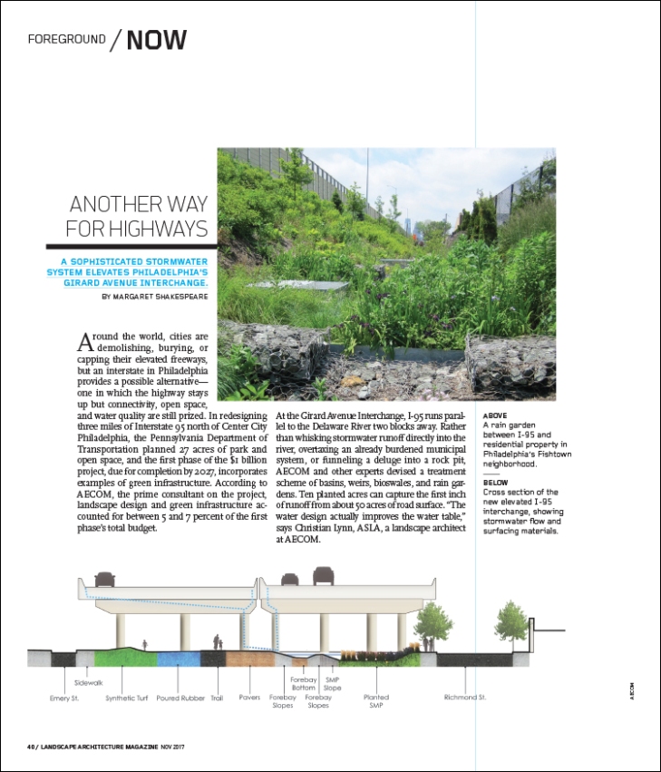
Around the world, cities are demolishing, burying, or capping their elevated freeways, but an interstate in Philadelphia provides a possible alternative—one in which the highway stays up but connectivity, open space, and water quality are still prized. In redesigning three miles of Interstate 95 north of Center City Philadelphia, the Pennsylvania Department of Transportation planned 27 acres of park and open space, and the first phase of the $1 billion project, due for completion by 2027, incorporates examples of green infrastructure. According to AECOM, the prime consultant on the project, landscape design and green infrastructure accounted for between 5 and 7 percent of the first phase’s total budget.
At the Girard Avenue Interchange, I-95 runs parallel to the Delaware River two blocks away. Rather than whisking stormwater runoff directly into the river, overtaxing an already burdened municipal system, or funneling a deluge into a rock pit, AECOM and other experts devised a treatment scheme of basins, weirs, bioswales, and rain gardens. Ten planted acres can capture the first inch of runoff from about 50 acres of road surface. “The water design actually improves the water table,” says Christian Lynn, ASLA, a landscape architect at AECOM.
Water resource engineer Edwina Lam, also with AECOM, explains, “Water hitting the pavement runs to a gutter line and then through a drainage system to surface-street level, where it is collected in a bioswale or rain garden. We’ve built an outlet structure for a hundred-year storm.” Water not absorbed by the ground or plants goes through filtration before entering conduits that take the cleaned water to the river; weirs control water volume. The design is meant to capture water so that it doesn’t overload the city water drainage system. “The two systems are separate,” Lam says. “The city is already managing household and commercial wastewater.”
Plantings are also “meant to be placemaking,” Lynn says. “They make the underneath spaces more engaging and soften the edges.” Reconfigured entrance and exit ramps for the interchange increased the distance between highway touch-down points, expanding areas of natural light as well as pedestrian access. Still, nearly 70 percent of the open space lies under the deck, so the team conducted a sun/shade analysis and then mapped planting zones before choosing a plant palette that includes species able to withstand low light. Lynn also considered tolerance for salt, pollution, stormwater, and other urban conditions. For the planted areas, AECOM brought in a highly porous soil mix with amendments that will absorb and dissipate pollutants to protect the nearby river.
Residents, in whose back or front yards this transformation is unfolding, have had a voice and a vote in many decisions, with computer models to help them imagine the changes. Already, some residents are taking ownership of the spaces, posting pictures of butterflies in flower beds and hanging bird feeders in the young trees, which the designers and engineers take as measures of success. More official gauges are coming from several university research projects: Graduate students at Villanova University and Temple University are tracking plant health and water volumes and monitoring weather.

![]()